Introduction
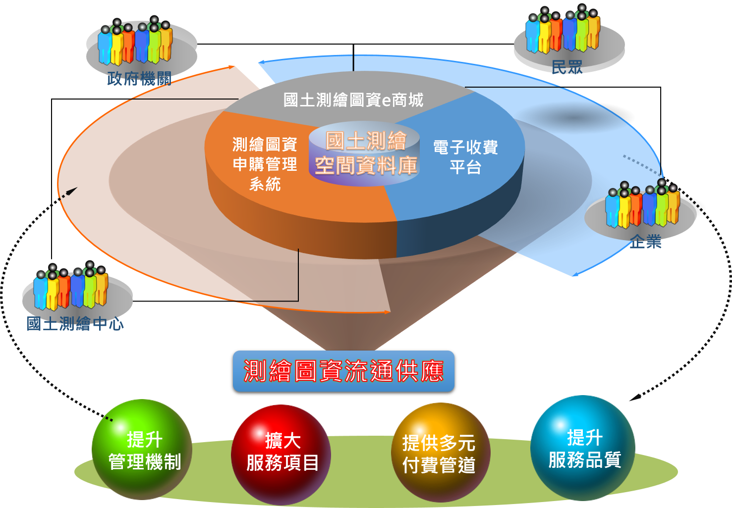
Land surveying and mapping data is the core and shared data of the land information system, and it is the basic data for overnment administration by various domestic agencies. In order to promote the circulation of surveying and mapping materials and give full play to the value of surveying and mapping materials, the National Land Surveying and Mapping Center uses data warehouse and spatial database. Based on the basis of Web GIS, Web Services and other network technologies, build a high-quality land surveying map data e-store to meet the map data needs of all walks of life.
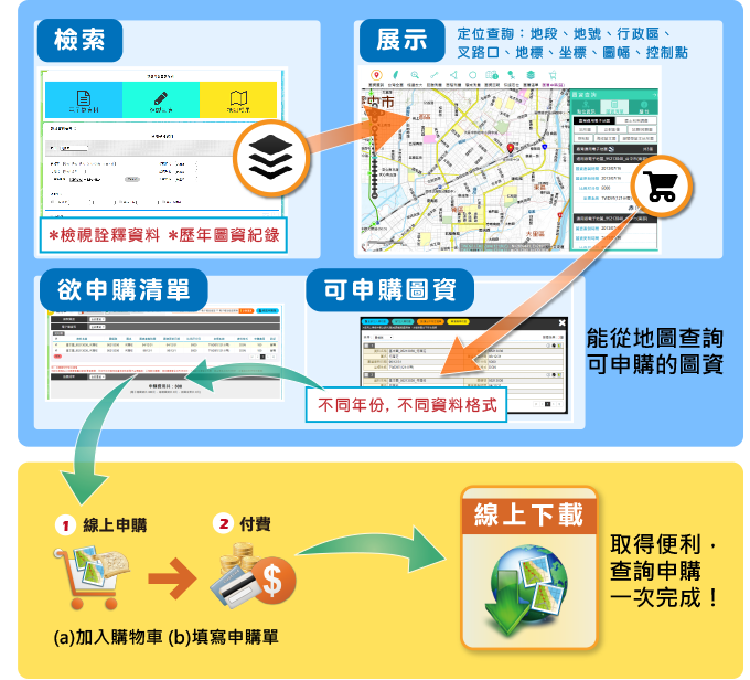
With the purpose of "convenient service", we introduce the concept of e-commerce business, integrate the cash flow and logistics mechanism, and fully electronicize the operations of "application for image information", "payment" and "download of image information" to provide friendly, convenient and efficient network services, construct a sustainable business environment, and improve the efficiency of the land surveying and mapping center in handling the circulation of surveying and mapping materials.

Project performance and benefits
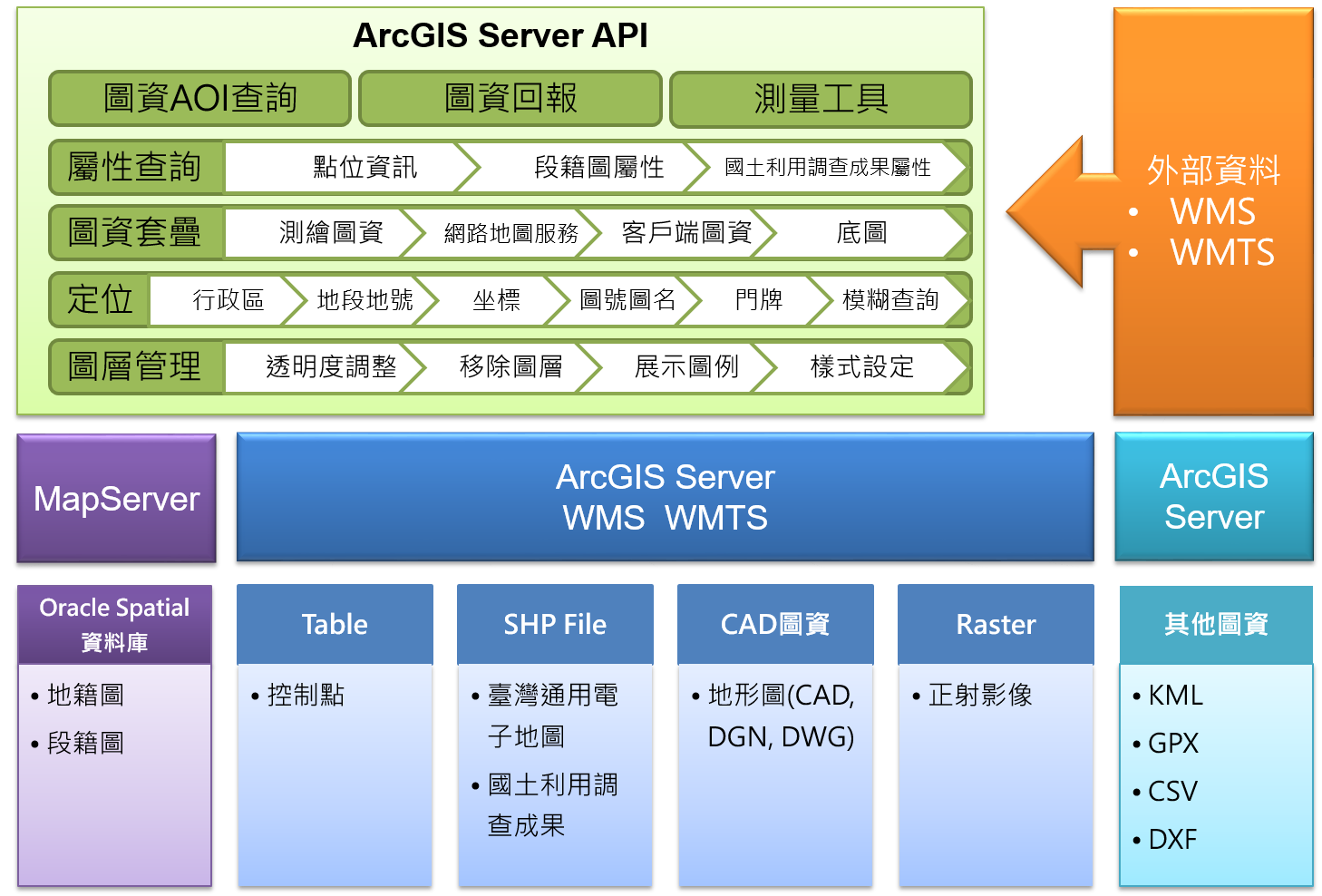
Planning and establishing a spatial database for land surveying and mapping, as the basis for the circulation and supply of surveying and mapping materials, can not only unify data sources, improve the integrity and availability of surveying and mapping data, but also simplify data maintenance and management complexity, strengthen data security and improve data management efficiency. Establish a one-stop service service for image data purchase, fully electronicize the operations of "image data application", "payment" and "map data download", provide friendly, convenient, and efficient network services; introduce automatic image data screening mechanism , to speed up the processing of map data purchase cases, improve the efficiency of the land surveying and mapping center in handling survey and map data circulation business, and achieve the purpose of simplifying administration and facilitating the people.
Establish a one-stop service service for image data purchase, fully electronicize the operations of "image data application", "payment" and "map data download", provide friendly, convenient, and efficient network services; introduce automatic image data screening mechanism , to speed up the processing of map data purchase cases, improve the efficiency of the land surveying and mapping center in handling survey and map data circulation business, and achieve the purpose of simplifying administration and facilitating the people.
Provide diversified payment channels, including ATM transfer, supermarket payment, online cash flow (integration of e-government charging services: credit card, financial account, chip financial card), mobile payment (Taiwan Pay), etc., not only achieve the purpose of simplifying and facilitating the people. It also provides an interface mechanism to allow other application systems of the Land Surveying and Mapping Center to interface and use, shortening the development period and lowering the construction cost. It also provides automatic account reconciliation and related statistical report functions to simplify the operation manpower and achieve outstanding results.
It has repeatedly won the "NGIS Supply System Award" and "TGOS Circulation Service Award" in the TGOS platform franchise node performance evaluation activities, and also won the 103rd Ministry of the Interior Natural Person Certificate Public Application System Excellence Award, the 10th and 13th Golden Figure Award, Top 100 Innovative Products of the 106 Annual Information Month-Innovation Gold Award and other honors.